Aerial Imaging

Cost-effective environmental imaging services combining camera drone and cloud technology

As a drone pilot and operator registered with the Civil Aviation Authority (CAA) in the UK I’m able to offer a variety of commercial services in open countryside locations.

Mapping

On one privately owned site in the Surrey Hills AONB I mapped 32 hectares (79 acres) of part ancient, mixed broadleaf woodland.

Thousands of individual images were stitched together to create an orthomosaic, which was then exported as individual GeoTIFF tiles compatible with GIS software. Very high resolution single images can also be generated (2cm/pixel).

Mapping missions were flown at different times of year to observe seasonal variation.

Analysis

Spectral analysis techniques allow aerial imagery to be used for environmental monitoring at landscape scale. The image below compares visual spectrum vs. enhanced NDVI processing to study plant health.

Visual spectrum vs. NDVI showing replanted woodland

Change detection

Orthomosaic images facilitate accurate measurement to inform effective land management. The aerial map below quickly measured the extent of a heathland fire at Thursley Common NNR in Surrey for Natural England.

Aerial drone map showing extent of Thursley NNR heath fire

Monitoring

Below is an aerial survey of a Homes England residential development at the point where a new access road crosses a river valley intended to form a ‘green corridor’ for wildlife. Orthomosaic, NDVI and elevation visualisations are compared.

This short animation shows the image resolution (~2cm/pixel) attained from the same drone survey mission flown at an altitude of 100m.

Timelapse

By layering orthomosaic images created in different seasons it’s possible to create a wide area timelapse sequence, as shown below.

Drone vs. satellite

Drones and satellites offer complementary technologies for aerial imaging, but camera drones enjoy a few advantages:

  1. Resolution
    Satellites cannot compete with drones for detail. Satellite images will allow you to see individual trees, but with a drone it’s possible to distinguish each leaf.
  2. Perspective
    Satellites are restricted to flat overhead perspectives. A well-operated drone can film or photograph any subject from almost any angle. This can assist in the capture of digital elevation models using 3D point clouds.
  3. Urgency
    You don’t need to wait for cloud cover to clear before flying a drone survey! If clouds obscure your satellite image you have no option but to schedule another attempt… and cross your fingers.

Drone Mapping

Drone mapping
Drone mapping using a consumer level DJI Spark drone.

Experiment in environmental monitoring using a small consumer drone

For a few months now I’ve been experimenting with the use of a small camera drone for environmental monitoring. The quality of the resulting images and the unique perspective it offers have been pleasantly surprising. Its potential applications at relatively low cost are impressive I think.

Red Hill Henge

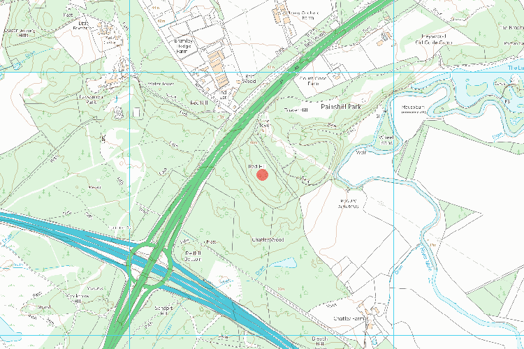
The site of this Scheduled Ancient Monument lies east of the A3 in Surrey and just north of Junction 10 on the M25 motorway.

Map of Red Hill Henge
Red Hill Henge scheduled Ancient Monument (1007905). © Crown Copyright and database right 2018.

‘Making the countryside pay’

In late 2017 Surrey County Council, in collaboration with Surrey Wildlife Trust, decided that this Site of Special Scientific Interest (SSSI) would be a suitable venue to pilot their commercial felling operations in the county.

A licence issued by the Forestry Commission permitted them to extract 30% on 2 occasions over a 10 year period. Upon visiting the site however the impact at ground level looked far more extensive than I would have expected.

Stacks of felled timber
Felling operations on Wisley & Ockham Commons SSSI

Concerned that contractors may have exceeded their remit and damaged the Scheduled Ancient Monument in the process I mapped an area to the north of the site, flying the drone in parallel lines at a height of 60 metres with the downward-facing camera set to take pictures at intervals every few seconds.

Cloud view

With the help of DroneDeploy’s internet cloud software I then stitched the resulting 139 overlapping images together to create an orthomosaic map layer.

Drone map
Area mapped by drone at Red Hill Henge in Surrey.
Orthomosaic map imagery
Orthomosaic detail from drone imagery at Red Hill Henge.

Tracks left by the contractor’s heavy machinery can be seen running across the circular ‘henge-like’ earth bank feature.

Switching to the Normalised Difference Vegetation Index (NDVI) imagery analysis clearly shows the difference between live green vegetation and felled woodland.

NDVI map
Normalised Difference Vegetation Index (NDVI) analysis of felled woodland.
NDVI map
Normalised Density Vegetation Index analysis of felled woodland.

Extra dimension

To help peopIe unfamiliar with the site to visualise the monument in context I then generated a 3D model from the visual point data using DroneDeploy’s online competitor, Pix4D.

3D model of ancient monument
3D model of Red Hill Henge generated from drone imagery.

For terrain features and dense canopy this technique works well, but it struggles to accurately represent isolated trees and finer features. Without resorting to an expensive aerial LiDAR platform it would be difficult to achieve better results however.

Bright Spark

The little drone done good on this occasion, and with minimal disturbance to this historically and environmentally sensitive site ironically.

DJI Spark drone
DJI Spark drone. Photo: Ralph Clark.