

Experiment in environmental monitoring using a small consumer drone
For a few months now I’ve been experimenting with the use of a small camera drone for environmental monitoring. The quality of the resulting images and the unique perspective it offers have been pleasantly surprising. Its potential applications at relatively low cost are impressive I think.
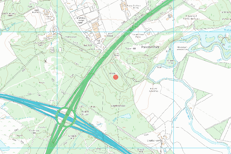
Red Hill Henge
The site of this Scheduled Ancient Monument lies east of the A3 in Surrey and just north of Junction 10 on the M25 motorway.
‘Making the countryside pay’
In late 2017 Surrey County Council, in collaboration with Surrey Wildlife Trust, decided that this Site of Special Scientific Interest (SSSI) would be a suitable venue to pilot their commercial felling operations in the county.
A licence issued by the Forestry Commission permitted them to extract 30% on 2 occasions over a 10 year period. Upon visiting the site however the impact at ground level looked far more extensive than I would have expected.

Concerned that contractors may have exceeded their remit and damaged the Scheduled Ancient Monument in the process I mapped an area to the north of the site, flying the drone in parallel lines at a height of 60 metres with the downward-facing camera set to take pictures at intervals every few seconds.
Cloud view
With the help of DroneDeploy’s internet cloud software I then stitched the resulting 139 overlapping images together to create an orthomosaic map layer.


Tracks left by the contractor’s heavy machinery can be seen running across the circular ‘henge-like’ earth bank feature.
Switching to the Normalised Difference Vegetation Index (NDVI) imagery analysis clearly shows the difference between live green vegetation and felled woodland.


Extra dimension
To help peopIe unfamiliar with the site to visualise the monument in context I then generated a 3D model from the visual point data using DroneDeploy’s online competitor, Pix4D.

For terrain features and dense canopy this technique works well, but it struggles to accurately represent isolated trees and finer features. Without resorting to an expensive aerial LiDAR platform it would be difficult to achieve better results however.
Bright Spark
The little drone done good on this occasion, and with minimal disturbance to this historically and environmentally sensitive site ironically.

