Aerial imaging

Cost-effective environmental imaging services combining camera drone and cloud technology

As a drone pilot and operator registered with CAA in the UK I’m able to offer a variety of commercial services in open countryside locations, where a full PfCO is not required.

Mapping

On one privately owned site in the Surrey Hills AONB I mapped 32 hectares (79 acres) of part ancient, mixed broadleaf woodland.

Thousands of individual images were stitched together to create an orthomosaic, which was then exported as individual GeoTIFF tiles compatible with GIS software. Very high resolution single images can also be generated (2cm/pixel).

Mapping missions were flown at different times of year to observe seasonal variation.

Analysis

Spectral analysis techniques allow aerial imagery to be used for environmental monitoring at landscape scale. The image below compares visual spectrum vs. enhanced NDVI processing to study plant health.

Visual spectrum vs. NDVI showing replanted woodland

Change detection

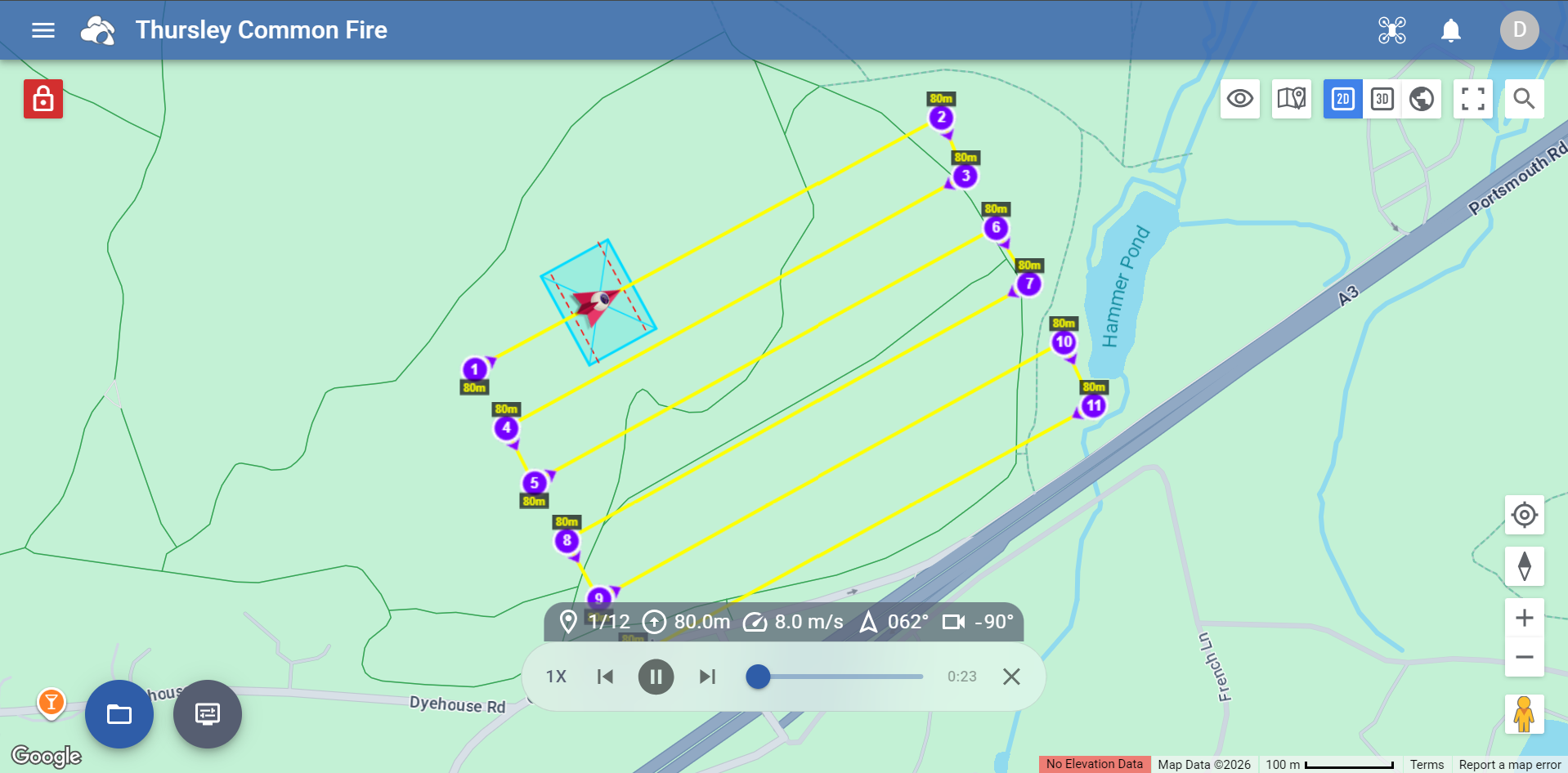
Orthomosaic images facilitate accurate measurement to inform effective land management. The aerial map below quickly measured the extent of a heathland fire at Thursley Common NNR in Surrey for Natural England.

Aerial drone map showing extent of Thursley NNR heath fire

Monitoring

Below is an aerial survey of a Homes England residential development at the point where a new access road crosses a river valley intended to form a ‘green corridor’ for wildlife. Orthomosaic, NDVI and elevation visualisations are compared.

This short animation shows the image resolution (~2cm/pixel) attained from the same drone survey mission flown at an altitude of 100m.
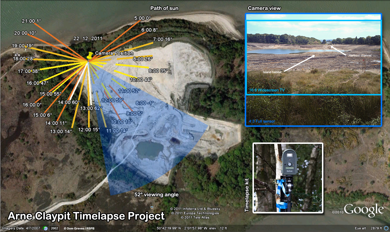
Timelapse

By layering orthomosaic images created in different seasons it’s possible to create a wide area timelapse sequence, as shown below.

Video

More conventionally, the video below shows scenes from a Bluebell wood in early spring. Bluebells are an attractive ancient woodland indicator species.

Drone vs. satellite

Drones and satellites offer complementary technologies for aerial imaging, but camera drones enjoy a few advantages:

  1. Resolution
    Satellites cannot compete with drones for detail. Satellite images will allow you to see individual trees, but with a drone it’s possible to distinguish each leaf.
  2. Perspective
    Satellites are restricted to flat overhead perspectives. A well-operated drone can film or photograph any subject from almost any angle. This can assist in the capture of digital elevation models using 3D point clouds.
  3. Urgency
    You don’t need to wait for cloud cover to clear before flying a drone survey! If clouds obscure your satellite image you have no option but to schedule another attempt… and cross your fingers.

Arne claypit reclamation

Post-industrial landscape reclaimed for wetland wildlife at RSPB Arne

The Arne peninsula in Dorset juts out into Poole Harbour, separating the Wareham channel from the main body of water. Right out at the tip, concealed by the remains of ancient oak woodland, lies a former ball clay pit.

The extraction company, Imerys, finished mining the deposit in 2008. Since 2010 they have been restoring the area as part of their mitigation agreement, before transferring ownership of the site to the RSPB, who manage the surrounding nature reserve at Arne.

Arne Claypit, July 2011

See immersive 360 degree view.

I was asked to document this reclamation process on behalf of the RSPB, in particular the flooding of the claypit basin with water from the harbour to create a saline lagoon habitat for wading birds and other species.

Earthworks

With mining activities ended the pit was re-profiled with heavy earth-moving equipment, and a layer of topsoil deposited above the expected final water level in the summer of 2011.

This slideshow requires JavaScript.

Next, a channel was cut through the embankment to join the claypit with the harbour at the south end of the site. On especially high tides the water from the harbour would flood this channel to gradually fill the lagoon.

This process was expected to take many months and it was decided to document the process with a timelapse camera.

View to a spill

We surveyed the best location for the camera – somewhere with a wide view of the pit, a glimpse of the harbour in the background, a small island in the middle ground and some vegetation in the foreground to provide varied visual interest.

Unfortunately this necessitated pointing the camera due south, so we also calculated the position and angle of the sun in future months to try to minimise its dazzling effect on the camera’s lens and sensor.

Arne claypit timelapse project plan

The pit itself is off-limits, but there is public access to the surrounding area and it is too remote to monitor. Exposure to the elements over such a long period was also a consideration, so an expensive DSLR setup was not a practical option, and a relatively cheap-and-cheerful alternative was sourced.

The pit filled much more rapidly than the engineers had predicted and in April of the following year, after only 7 months, the rising water had achieved its final level.

The following video sequence shows events over that period, compressed to just 1 minute, using stills taken at 3 hour intervals:

Life returns

The island habitat is already frequented by shelducks and sika deer regularly visit its shores. It will take longer for the waters to settle and for other species to establish themselves.

It’s hoped that the regular interchange of water with the harbour will prevent the process of eutrophication, which would otherwise make the lagoon inhospitable. The suspension of clay particles in the water can be a serious problem in this respect.

Arne claypit reclamation stills sequence

Whether this industrially exploited area becomes the wildlife oasis hoped for only time will tell.

With thanks to Mark, Rob, Damon, James and Em at RSPB Arne.