Meet our amazing mygalomorph, discover its life cycle and learn how to find it
The scarce Purse Web Spider (Atypus affinis) is rarely seen because it spends the majority of its life underground in a sock-shaped tube. In the UK it has the honour of being our only member of the mygalomorph family, which elsewhere includes tarantulas.
Male Purse Web Spider (Atypus affinis) on heathland. Dorset, UK.
Purse Web Spiders normally lead a solitary existence in a silk-lined burrow. The top portion of this tube extends above ground and is extremely well camouflaged with its surroundings, covered with bits of vegetation and debris. Most of the time this tube is completely sealed.
Camouflaged web of Purse Web Spider (Atypus affinis) on heathland. Surrey, UK.Female Purse Web Spider (Atypus affinis) female in tube web. Sussex, UK.Female Purse Web Spider (Atypus affinis) female in tube web. Sussex, UK.
When the Purse Web Spider’s prey makes contact with the exposed section of burrow the spider senses its vibrations and bites through the silk with its huge fangs. These distinctive downward-facing ‘chelicerae’ are shared with its larger, more exotic, arachnid ancestors. The fangs of more modern spiders cross over.
Male Purse Web Spider (Atypus affinis) on heathland. Dorset, UK.
In spring and autumn each year male Purse Web Spiders leave their burrows to go wandering in search of females. This is when you are most likely to find an adult spider. If successful in his quest he tears an entrance in her silk tube and, after mating, the pair will live here together for a while.
In early spring each year juvenile Purse Web Spiders exit the nest burrow and climb surrounding vegetation. They weave thick lines of silk to aid dispersal, and build tent-like structures around which they initially congregate.
Purse Web spiderlings (Atypus affinis) dispersing. Surrey, UK.Purse Web spiderlings (Atypus affinis) create silk rigging. Surrey, UK.
Locating this silk rigging is a good indication that an adult’s burrow is nearby. Look out for it at the top of low gorse or heather on heathland in the south of England from mid-March. This species can also be found on chalk grassland.
Silk tents constructed by Purse Web spiderlings (Atypus affinis) on heathland. Surrey, UK.
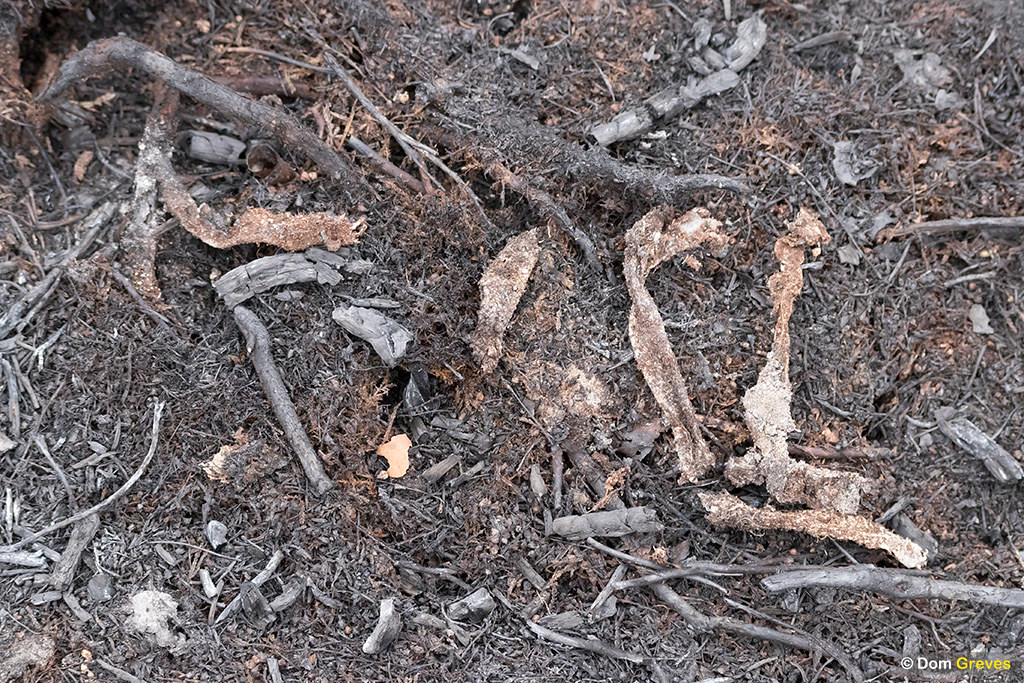
In the aftermath of heath fires, discarded sections of Purse Web tubes become more visible. Heat damages the surface layer of camouflage, exposing brighter silk beneath.
Discarded Purse Web Spider (Atypus affinis) tube webs on burnt heathland. Surrey, UK.Discarded Purse Web Spider (Atypus affinis) tube webs recovered from burnt heathland. Surrey, UK.
The Purse Web Spider is classified as Nationally Scarce and is Amber Listed. Although it remains widespread, the species has undergone substantial decline. However there is limited data available and so the British Arachnological Society (BAS) has launched a new Purse Web Spider Recording Scheme using iRecord. If you find one of these amazing creatures please be sure to let them know!
One very soggy White Admiral caterpillar this evening, draped across his former hibernaculum. There were streams in the wood where I haven't seen water before. 🦋🐛⛈️ #WhiteAdmiralWatchpic.twitter.com/LDmxvXKG7S
The reason for Rollo’s delayed development becomes clear…
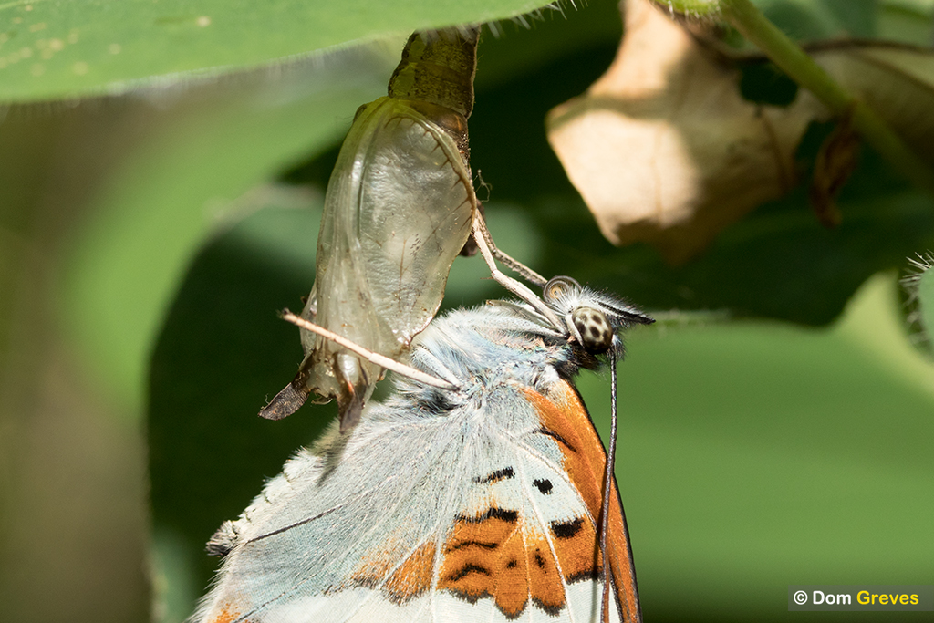
A fly was over-eager to pay its last respects to my parasitised White Admiral caterpillar. But even in this near-fatal condition Rollo summoned the energy to lash out with his head! #WhiteAdmiralWatchpic.twitter.com/RgCOWbHhxg
White Admiral butterfly metamorphosis: from larva to prepupa to pupa to imago.
In Sussex during the COVID-19 epidemic of 2020 I followed one very special butterfly through pupation to emergence
The White Admiral (Limenitis camilla) is a large woodland butterfly which glides effortlessly along forest rides. Its numbers in the UK have rebounded since the First World War, possibly due to the cessation of coppicing which, unusually, has benefited this species since its larvae require Honeysuckle growing in shady woodland.
28 May
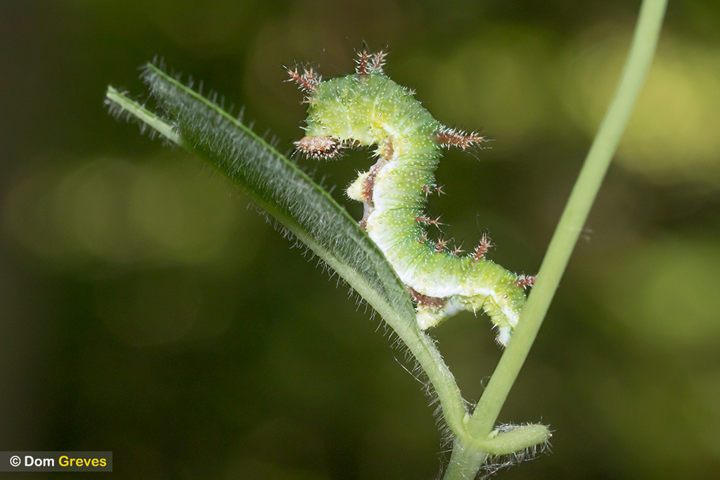
My first, long awaited, encounter with ‘Camilla’ came on 28 May when my many searches of Honeysuckle vines finally bore fruit and this magnificent creature suddenly greeted me.
White Admiral (Limenitis camilla) 5th instar caterpillar on honeysuckle (Lonicera periclymenum).
White Admiral caterpillars are entirely dependent on Honeysuckle for their survival, feeding on its leaves through all five larval instars and hibernating within their folds.
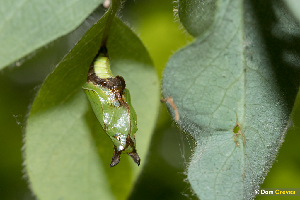
At more than 2 cm in length this was a fifth and final stage caterpillar, exotic in appearance compared to the majority of British butterfly larvae, adorned with branching red spines along its back and resting in a raised serpentine position.
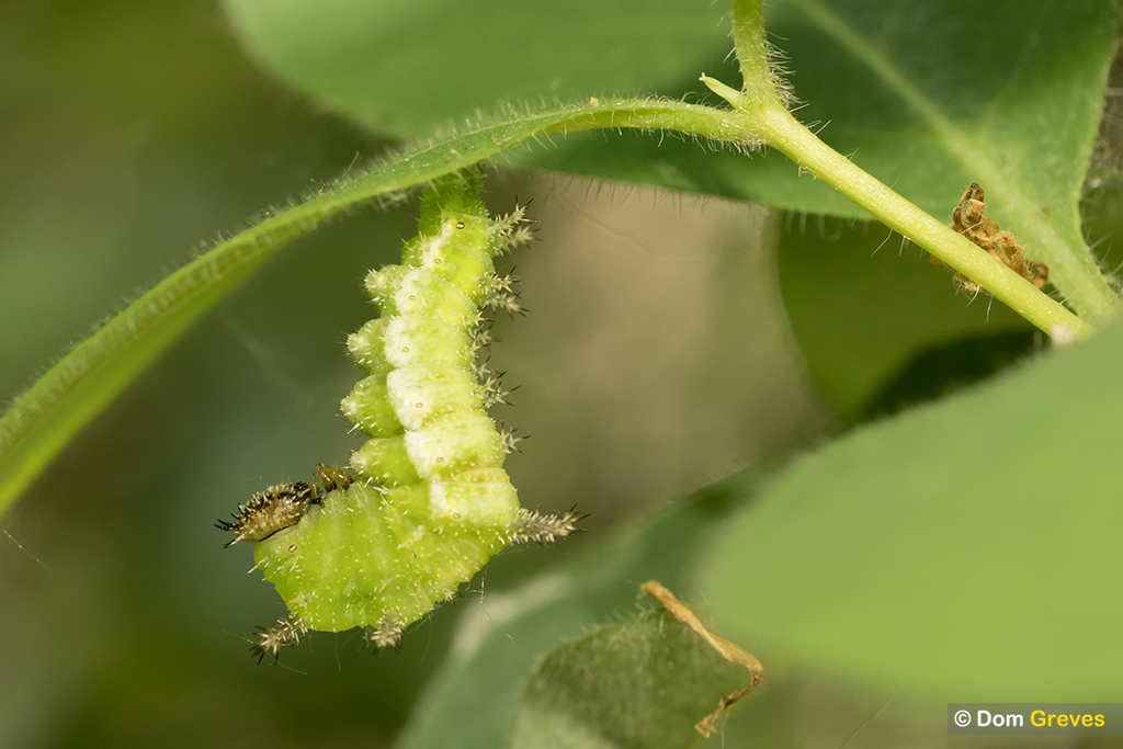
31 May
When I returned 3 days later Camilla was already preparing to pupate, hanging beneath a Honeysuckle leaf, suspended from her hind claspers attached to a pad of silk.
White admiral (Limenitis camilla) prepupa suspended from honeysuckle (Lonicera periclymenum).
2 June
48 hours later the pupa was now fully formed, with two prominent horns on the head and an odd protrusion further back.
“The pupa bears a close resemblance to a profile portrait of Punch.”
– Frohawk (1924)
White admiral (Limenitis camilla) pupa suspended from honeysuckle (Lonicera periclymenum). Day 1.
7 June
The pupa darkened up a little in the next few days, its undulations mimicking the Honeysuckle leaves quite convincingly.
White admiral (Limenitis camilla) pupa suspended from honeysuckle (Lonicera periclymenum). Day 6.
For the next two weeks few visible changes occurred and the weather turned cold and wet. A marauding army of small birds came and went, leaving Camilla thankfully undisturbed.
23 June
Around Day 22 the folded wing veins became a bit more pronounced beneath the pupal case and its body seemed to have plumped up a bit. Warm, sunny weather had returned to the woodland glade.
White admiral (Limenitis camilla) pupa suspended from honeysuckle (Lonicera periclymenum). Day 22.
24 June
Revisiting on the morning of Day 23 I found Camilla had darkened up overnight, turning from green to brown, signalling that ‘eclosion’ of the adult butterfly was imminent.
White admiral (Limenitis camilla) pupa suspended from honeysuckle (Lonicera periclymenum). Day 23 (AM).
By 5pm that afternoon my ‘White’ Admiral was now distinctly black!
White admiral (Limenitis camilla) pupa suspended from honeysuckle (Lonicera periclymenum). Day 23 (PM).
From a different angle the butterfly’s wing structure and patternation could clearly be seen.
“Before emergence it turns to a bronze-black all over, losing almost all the metallic lustre of silver-gilt; the white wing markings of the imago show pale amber colour through the pupal skin.”
– Frohawk (1924)
White admiral (Limenitis camilla) pupa suspended from honeysuckle (Lonicera periclymenum). Day 23 (PM).
I was hopeful the adult butterfly would emerge that evening and so remained until well after dusk, but as it grew dark I was forced to return home for the night.
25 June
Back on site very early next morning I was relieved to discover that the big moment had yet to arrive.
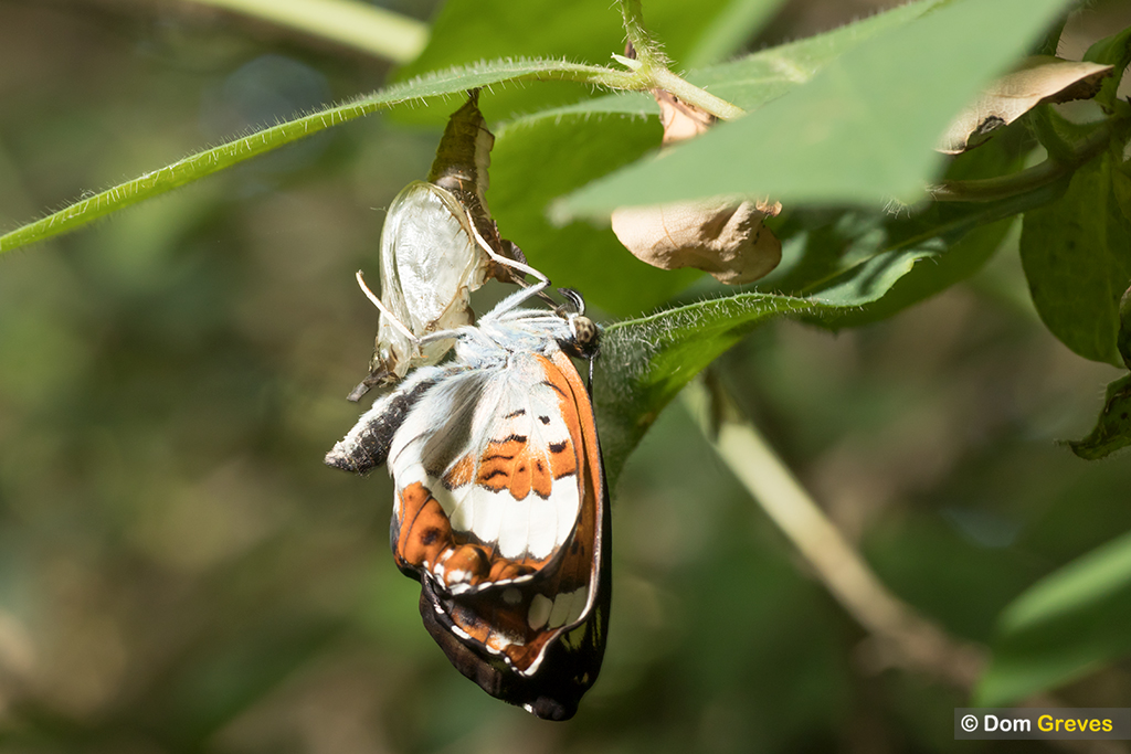
Camilla remained suspended from the Honeysuckle leaf until 09:11 on Day 24 when she suddenly popped out of her chrysalis in the blink of an eye, annoyingly while my back was briefly turned!
White admiral (Limenitis camilla) imago newly hatched. Day 24.
Camilla luxuriated in the warm morning sunlight streaming through the oak canopy, slowly expanding her glorious wings as she clung to the vacant ‘exuvia’.
White admiral (Limenitis camilla) imago newly hatched. Day 24.
By 10:50 her wings were fully expanded and at 11:12, two hours after emergence, she clambered nimbly up onto the Honeysuckle leaf which had supported her pupa through sun and rain, heat and cold, for the past 24 days. It would now become her launching pad.
White admiral (Limenitis camilla) imago shortly before first flight.
And then 8 minutes later, at 11:20 she flew for the first time… and was gone!
Video showing newly emerged White Admiral (Limenitis camilla) butterfly drying its wings before takeoff.
Except that I strongly suspect she hung around…
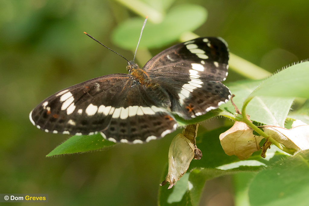
I only witnessed one other adult White Admiral in the wood that summer. The individual photographed below frequented Bramble blossom within metres of Camilla’s hatching site, sunning itself on the woodland floor nearby and alighting on Honeysuckle, likely assessing suitable spots to lay her eggs for the next generation of White Admiral caterpillars to emerge.
White admiral (Limenitis camilla) butterfly nectaring on bramble flowers.
Common toad (Bufo bufo) crossing a road at night on migration to breeding pond. Sussex, UK.
After emerging from hibernation in early spring common toads (Bufo bufo) migrate back to their breeding ponds at night. Sometimes this involves crossing busy roads and many toads are sadly hit and killed by passing cars.
Each year volunteers working with charities such as Froglife and local Amphibian and Reptile Groups attempt to ferry migrating toads, frogs and newts to safety at known crossing points.
Toad crossing signage. Sussex, UK.Common toad (Bufo bufo) juvenile recovered at road crossing on spring migration. Surrey, UK.Toads retrieved from road in a bucket
Male toads grasp females in a position known as ‘amplexus’ as they attempt to fertilise her eggs. Often a mating pair can be found together before they reach the nearest pond. When this happens males hitch a free ride!
Common toads in amplexus while crossing a road on spring migration
I was delighted to see my work featured in Erica McAlister’s new book on diptera: ‘The Inside Out of Flies’, published by London’s Natural History Museum last month.
The Inside Out of Flies by Erica McAlister
The photograph in question shows hundreds of eggs laid by a member of the horse fly family (Tabanidae).
Horse fly eggs featured in The Inside Out of Flies
Erica uses the reproductive strategy of horse flies to illustrate r/K selection theory:
r-selected species are seen as more opportunistic and are able to propogate more quickly if the environment is suitable, whereas K-strategists spend more time investing in a few offspring to give them whatever competitive advantages they can to prosper in what are often already crowded niches
The original image from my archive is shown below:
Horse fly eggs (Tabanus cordiger?) on salad burnet (Sanguisorba minor) stem. Surrey, UK
Related links
See more Invertebrate images on my photographic website
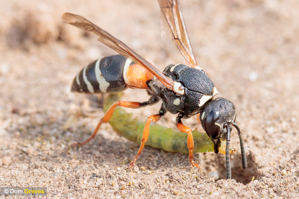
In the UK the rare Purbeck mason wasp (Pseudepipona herrichii) is found only in the Isle of Purbeck, Dorset.
The female excavates a nest burrow in bare ground on heathland and later seals it with moistened clay.
Purbeck mason wasp (Pseudepipona herrichii) excavating nest burrow on heathland. Dorset, UK.
She stocks her burrow with the larvae of a small moth which feeds mainly on bell heather.
Purbeck mason wasp (Pseudepipona herrichii) with Acleris hyemana moth larva prey at nest burrow entrance. Dorset, UK.
The adults chew distinctive holes in the heather flowers to obtain nectar which their short tongues could not otherwise reach.
Purbeck mason wasp male nectaring on bell heather. Dorset, UK.
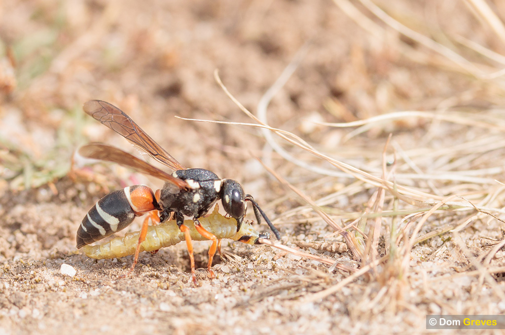
The Purbeck mason wasp is thought to rely solely on the larvae of Acleris hyemna, but in 2017 I photographed this female provisioning her nest with what appears to be the moth Acleris notana.
Purbeck mason wasp (Pseudepipona herrichii) with moth larva prey (Acleris notana?) at nest burrow entrance. Dorset, UK.
The fly orchid (Ophrys insectifera) is usually found on chalk and limestone soils in open deciduous woodland and scrub, but is also recorded from grassland and chalk-pits. It is rare in the UK and even at known locations can be difficult to spot.
Fly orchids in woodland clearing. Surrey, UK.
Fly orchids are in flower between May and June. At this time they attract male digger wasps (Argogorytes mystaceus) with a scent which closely resembles the female wasp’s pheromone.
Males attempt to copulate with the orchid and during this process pollinia become attached, which may be carried to the stigma of another flower, completing pollination.
Male digger wasp (Argogorytes sp.) pseudocopulating with fly orchid (Ophrys insectifera).Fly orchid pollinia attached to the head of male digger wasp.
I was finally lucky enough to observe and document this behaviour in the Surrey Hills earlier this year.
Advancing conservation science through public engagement on digital platforms
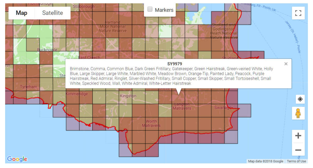
Working for the Dorset branch of Butterfly Conservation I developed an online system to document sightings of butterflies submitted by members of the public. This ‘citizen science’ project encourages engagement in nature conservation and adds to our knowledge of these important environmental indicator species.
Since 2014 this recording system has gathered more than 700,000 individual adult butterfly sightings, contributing to our understanding of these beautiful creatures and the changing world we inhabit.
700,000+ individual butterfly sightings
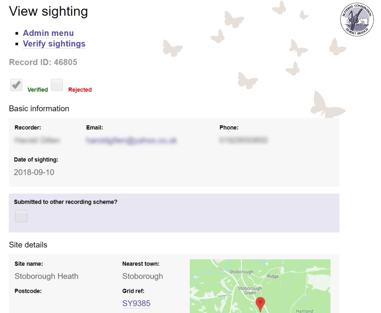
Capture
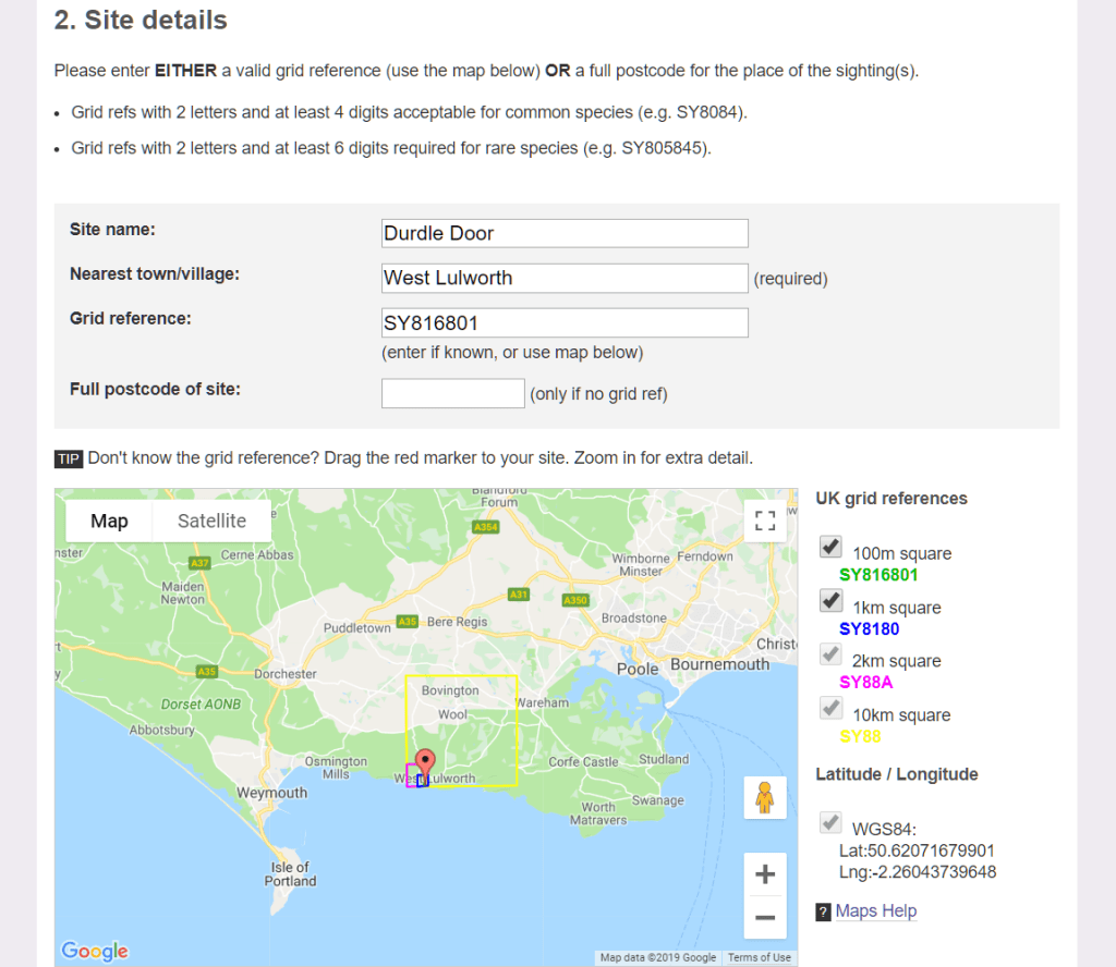
Butterfly spotters are directed to a web form which collects personal info, location details including grid reference, and species observed.
Butterfly recording form: recorder info
Butterfly recording form: site details
This information is then inserted into the Dorset Branch web sightings database.
Verify
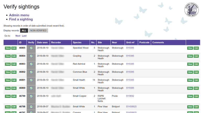
Local experts are given password-protected access to a record management interface on the branch website. Recently submitted butterfly sightings can be reviewed and verified with a single click.
Butterfly record verification
Questionable records can be studied in more detail and individuals contacted to clarify information as necessary.
Butterfly record management view
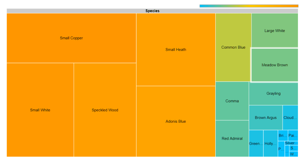
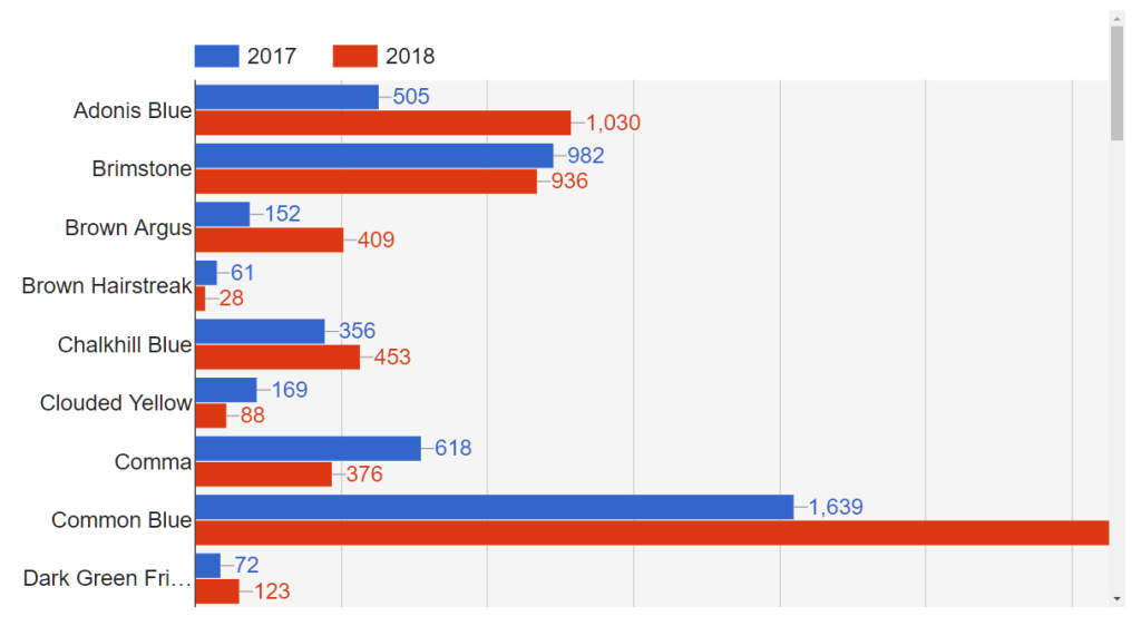
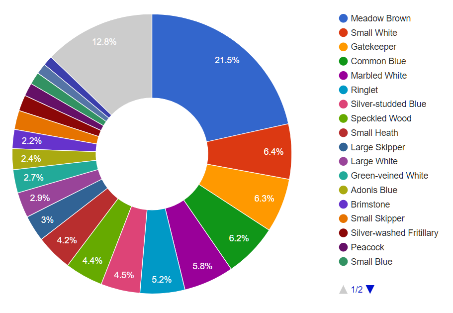
Interpret
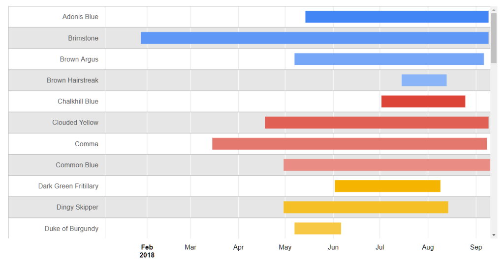
Verified records are instantly published to the branch website, using a number of graphical representations for easy interpretation.
Butterfly data: map
Butterfly data: tree chart
Butterfly data: calendar
Butterfly data: bar chart
Butterfly data: pie chart
Butterfly data: Gantt chart
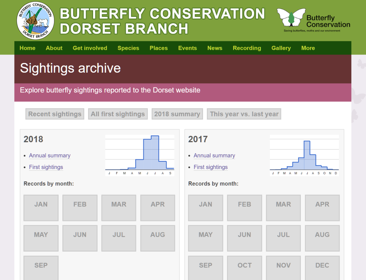
Archive
Butterfly sightings received via the website are archived online for the public to explore in greater depth.
Butterfly data: archive
Share
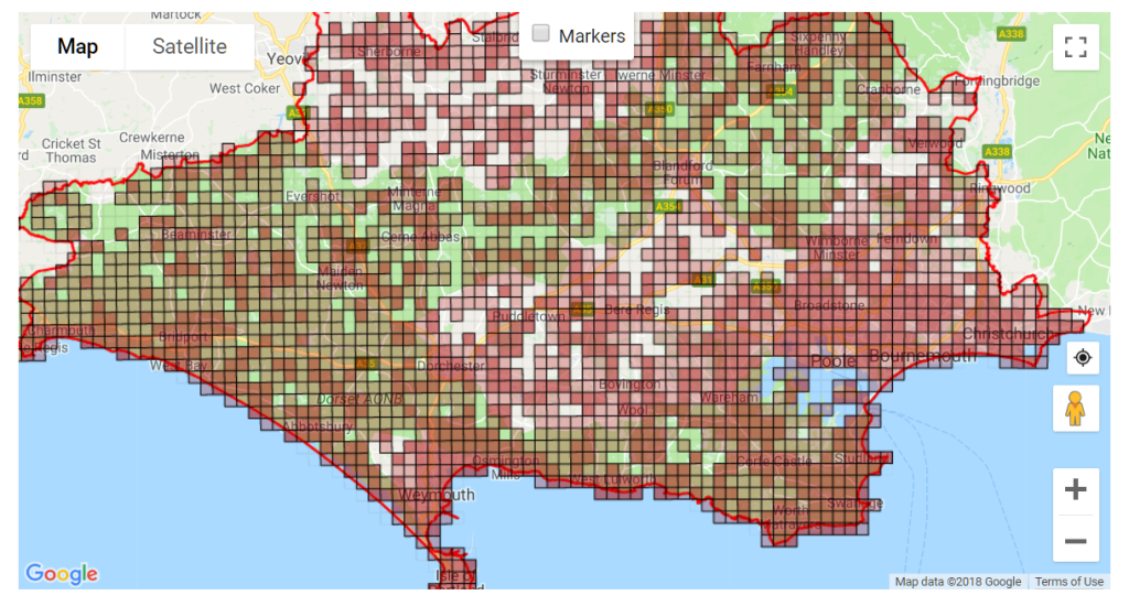
Casual sightings received via the branch website provide a useful snapshot of butterfly activity in Dorset, but for research purposes it’s necessary to combine them with data from formally structured butterfly transects, and other recording schemes within the region and nationally.
Website data is exported to the national society’s database annually. National butterfly recording cycles run for 5 years, at the end of which a Butterfly Atlas for Dorset is produced, showing the updated distribution of species and population trends.
Adonis Blue distribution data superimposed on map revealing underlying geological strata
Coordinate
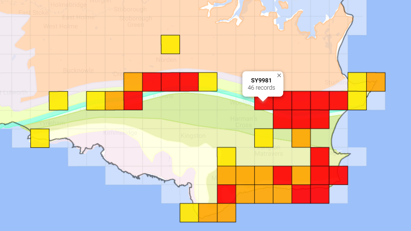
To encourage recording in under-represented areas an interactive ‘White Holes’ map is published on the branch website. This combines data from the national database with more up-to-date regional web sightings.
Butterfly data: White Holes map
Butterfly data: White Holes map detail
It’s possible to use this map on a GPS-enabled mobile device to locate the nearest White Hole for observation. A list of previously recorded species for each 1km square is also presented.
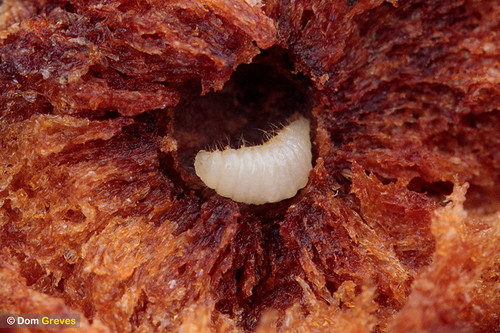
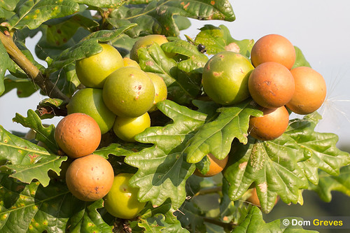
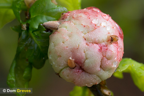
Oak trees are home to more than 30 species of gall wasp. The larval stage of these insects induce the plant to produce abnormal growths, known as galls, which enclose and protect them as they develop.
Galls come in a variety of fantastical shapes, each unique to particular species.
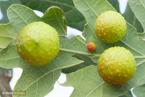
Oak marble gall
Hard woody spherical galls up to 25mm in diameter on the oak stems. Initially green but later become brown.
Created by: Andricus kollari
Oak apple gall
These galls have a spongy texture and are brownish white, tinged with pink.
Created by: Biorhiza pallida
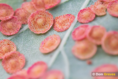
Common spangle gall
Yellowish gingery brown disc-shaped galls on the underside of oak leaves in late summer and early autumn.
Created by: Neuroterus quercusbaccarum
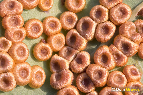
Silk button spangle gall
Golden brown discs with a depressed centre on the underside of oak leaves in late summer through to early autumn.
Created by: Neuroterus numismalis
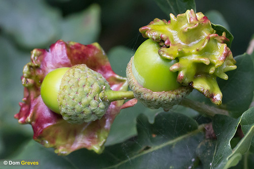
Knopper gall
The acorn becomes a ridged woody structure. The gall is initially yellowish green and sticky but later greyish brown.
Created by: Andricus quercuscalicis
Cherry gall
Yellowish green or red spherical galls up to 20mm in diameter on the underside of oak leaves in late summer and autumn.
Created by: Cynips quercusfolii
It gets complicated…
Oak gall wasps have complex life cycles, with alternating generations that are either sexual with males and females, or asexual with females only.
The two generations of wasp often produce different types of gall on different parts of the tree, and in some species the two generations alternate between native and non-native species of oak.
There are also wasps which specialise in injecting their eggs into oak galls. Their larvae then eat the resident eggs or larvae before they emerge.
The example above shows a type of Chalcid wasp investigating a fresh oak marble gall.
Open Air Laboratories (OPAL) was a UK-wide citizen science initiative which ran from 2007 – 2019, enabling people to get hands-on with nature while contributing to important scientific research. It was funded by the Big Lottery Fund and led by Imperial College London, in collaboration with Natural History Museum, Open University and Field Studies Council, supported by a network of Community Scientists.
OPAL designed a collection of field and desk-based activities suitable for all ages, abilities and backgrounds. It launched a series of national ecological surveys with activities intended to increase understanding of the natural environment, through data collection covering wildlife and habitat conditions.
I worked at OPAL from 2015 – 2016 as their Web and Digital Manager. OPAL’s successes included: